Updated 3D Map Model Release Notes
Not all map styles may be available on
MakerWorlddue to MakerWorld’s low file size limits.
All styles are available on Printables.
Unless otherwise specified for specific maps, I have designed the models for a 0.4 mm nozzle diameter and 0.08-0.12mm layer heights. Recommended print settings are any multiples of these specs but other nozzle sizes (and line widths) will print well too.
📢 Cautionary Remark on Accuracy: You may find other small scale maps with the description of “most detailed/accurate/quality models available” mixed in terms like LIDAR and satellite. These claims often lack quantifiable resolution and scale. My published maps’ specifications are tracked throughout stages of GIS and 3D processing. A modern FDM printer from Bambu Lab or Ultimaker will print near indistinguishable results between 0.1mm map models and 10x downscaled resolution as coarse as 1mm — determined through testing. If you are printing landscape maps covering wider than a city ≥50km (31mi), the map projection, smoothing, and scale have a greater effect on the final map detail and appearance.
Map Variants Comparison
My maps are created with 2 different elevation scale styles.
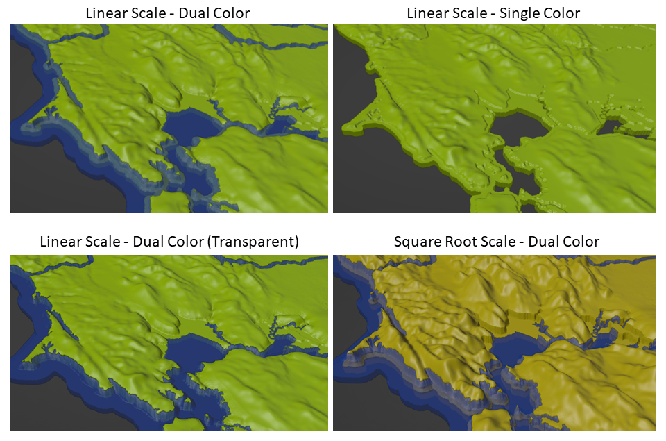
Linear Scale (linear): reflects the true elevation with a constant multiplier applied evenly across all the entire map to show sufficient detail.
Logarithmic Scale (incl: Square Root sqrt): exagerrates elevation differences in flat locations while smoothing out the pointyness of extreme elevations. Elevation detail is enhanced across the entire map at the cost of decreased accuracy.
Model Filename Chart
The map model style can be decoded and sorted by the filename.
REGION-ESCALING-EXTRUDER-STYLE-REVISION-POSTPROCESS-PIECE##.3mf
      │                       │
      └────────VARIANT────────┘
| Definition | Meaning |
|---|---|
REGION |
REGION Abbreviation |
ESCALING |
Elevation scaling (e.g., linear or sqrt or log) |
EXTRUDER |
dual or single color (extrusion) model |
STYLE* (optional) |
Model special style or subregion. (e.g. transparent) STYLE is only present when the model file is a special style or the model is exclusive to a special subregion. |
REVISION |
Revision number in the format Vxx where xx is the version. See release notes for the latest improvements. |
POSTPROCESS (optional) |
Secondary style (e.g.,lowpoly) based on a map VARIANT combination. |
PIECE##† (optional) |
Interlocking pre-cut piece ## sized for 180 mm x 180 mm or 256mm x 256mm bed. |
*Default STYLE is water features model located over submerged low lying lands. This submerged land may be visible when water layers are printed with a transparent filament. Default style minimizes usage of secondary (water) filament color. transparent style has water model features that extend all the way through the land for maximum light transmission when used with glow and transparent filaments.
†If multi-part files are not present, I have not created interlocking models for this state yet. Follow me on MakerWorld/Printables and comment with your request to get future additions and updates.
USA Individual States and Territories
Download on Printables and MakerWorld
| Map Specification | Value | Notes |
|---|---|---|
| Projection | USA Contiguous Lambert Conformal Conic | |
| Projection (Alaska) | NA Lambert Conformal Conic | |
| Projection (Hawaii) | UTM zone 4N | |
| Horizontal Scale | 1:2500000 (0.4mm:1000m) | Effective resolution is 1000m x 1000m. |
| Horizontal Scale (Alaska) | 1:2500000 (0.4mm:1000m) | Effective resolution is 2000m x 2000m. |
| Vertical Scale (Linear) | 1:500000 (0.1mm:50m) | Vertical exaggeration is 5x. Elevations 0-40m are scaled between 0 and 0.8mm on a logarithmic scale for enhanced coastal detail. |
| Vertical Scale (Square Root) | 1:500000 (0.1mm:50m) | Vertical exaggeration ranges from 285-5x between sea level and ~4000m. Scaling is greater at lower elevation and lower at higher elevation, . Linear and Square Root elevation breakover at ~4000m. |
| Vertical Scale (Low Poly) | Vertical exaggeration is 3x of the base map vertical scale. E.g. Linear base map 5x * low poly 3x = final 15x. | |
| 3D Model Resolution | 0.1mm | |
| 3D Model Resolution (Low Poly) | 0.1mm-2mm | |
| 3D Model Resolution (Alaska) | 0.2mm | |
| Highlights | Streams, Lakes, Coastlines | |
| Maritime Boundary | Submerged Lands Act | Seaward boundary of coastal states generally 3 or 9 nm from the coastline. Maritime boundaries are included in the dual print models. |
| Model Base Thickness at Sea Level | ~0.9mm | Additional +0.9mm (dual) / +0.4mm (single) for locations not covered by water. |
| Model Base Thickness at Sea Level (Low Poly) | ~0.9mm | Additional +4.5mm (dual) / +1.2mm (single) for locations not covered by water. |
Lower 48 (Contiguous) USA Map with Borders (all in one)
Download on MakerWorld
| Map Specification | Value | Notes |
|---|---|---|
| Projection | USA Contiguous Lambert Conformal Conic | |
| Horizontal Scale | 1:20000000 (0.4mm:8000m) | Effective resolution is 2000m x 2000m. |
| Vertical Scale (Linear) | 1:500000 (0.1mm:50m) | Vertical exaggeration is 40x. |
| Vertical Scale (Logarithm) | 1:500000 (0.1mm:50m) | Vertical exaggeration ranges from 27000-45x. Scaling is greater at lower elevation and lower at higher elevation. 45x is at ~5000m elevation. |
| 3D Model Resolution | 0.1mm | |
| Highlights | State borders | |
| Model Base Thickness at Sea Level (Linear) | 5mm | |
| Model Base Thickness at Sea Level (Logarithm) | 2mm |
USA Hyper Local Regions
Williamstown, MA, USA - Dual Color (NOV2023)
Download on Printables
| Map Specification | Value | Notes |
|---|---|---|
| Projection | UTM 18N | |
| Horizontal Scale | 1:36000 (0.5mm:18m) | Effective resolution is 20m x 20m. |
| Vertical Scale (Linear) | 1:36000 | |
| 3D Model Resolution | 0.2mm | |
| Highlights | Water, Highways, Streets | |
| Model Base Thickness at Sea Level | 0.0mm | Additional +0.27mm for unhighlighted locations. |
Oahu, HI, USA - Dual Color (NOV2023)
| Map Specification | Value | Notes |
|---|---|---|
| Projection | UTM 4N | |
| Horizontal Scale | 1:500000 (0.4mm:200m) | Effective resolution is 200m x 200m. |
| Vertical Scale (Linear) | 1:100000 (0.1mm:10m) | Vertical exaggeration is 5x. Elevations 0-40m are scaled between 0 and 0.8mm on a logarithmic scale for enhanced coastal detail. |
| Highlights | Coastal Outline | |
| Model Base Thickness at Sea Level | 1.2mm | Additional +0.27mm for unhighlighted locations. |
Israel + Palestine
| Map Specification | Value | Notes |
|---|---|---|
| Projection | Israeli Transverse Mercator (ITM) | |
| Horizontal Scale | 1:2500000 (0.4mm:1km) | |
| Vertical Scale (Linear) | 1:100000 (0.1mm:10m) | Vertical exaggeration is 5x. Elevations 0-40m are scaled between 0 and 0.8mm on a logarithmic scale for enhanced coastal detail. |
| Highlights | Streams, Lakes | 500m wide streams |
| Model Base Thickness at Sea Level | ~0.9mm | Additional +0.9mm (dual) / +0.4mm (single) for locations not covered by water. |
Iran
| Map Specification | Value | Notes |
|---|---|---|
| Projection | Web Mercator | |
| Horizontal Scale | 1:5000000 (0.4mm:2km) | |
| Vertical Scale (Linear) | 1:100000 (0.1mm:10m) | Vertical exaggeration is 5x. Elevations 0-40m are scaled between 0 and 0.8mm on a logarithmic scale for enhanced coastal detail. |
| Highlights | Streams, Lakes, Coastlines | 500m wide streams |
| Model Base Thickness at Sea Level | ~0.9mm | Additional +0.9mm (dual) / +0.4mm (single) for locations not covered by water. |
China
China model is at same scale as USA except for the following. Streams and base thickness are 4x thicker so that model can be more easily printed at 25% scale.
Download on Printables
| Map Specification | Value | Notes |
|---|---|---|
| Projection | Asia North Lambert Conformal Conic | |
| Horizontal Scale | 1:2500000 (0.4mm:1000m) | Effective resolution is 4000m x 4000m. |
| Vertical Scale (Linear) | 1:500000 (0.1mm:50m) | Vertical exaggeration is 5x. Elevations 0-40m are scaled between 0 and 0.8mm on a logarithmic scale for enhanced coastal detail. |
| Vertical Scale (Square Root) | 1:500000 (0.1mm:50m) | Vertical exaggeration is greater at lower elevation and lower at higher elevation, ranging from 285-5x between sea level and ~4000m. Linear and Square Root elevation breakover at ~4000m. |
| 3D Model Resolution | 0.2mm | |
| Highlights | Streams, Lakes | 4000m wide lines |
| Model Base Thickness at Sea Level | ~1.2mm | Additional +0.9mm (dual) / +0.4mm (single) for unhighlighted locations. |
Data
Data is freely available from NASA, USGS, USCB, HydroLAKES, Marine Cadastre, and state NR/GIS departments. Please remember to support national and local natural resource protection and research — this data would not be available otherwise.